I'm a relatively new iFly user and really enjoying it so far! As an IT professional and longtime user of compact EFBs / Flight-Computers, I appreciate the sweet-spot that iFly hits in terms of simplicity, performance, and value.
Because of the cockpit layout in my Homebuilt airplane, I have to use my tablet (iPad Mini) in landscape mode. This results in relatively little map being drawn "ahead" of the aircraft when in Track Up mode (or when flying N/S in North Up mode). Zooming out to see further along my intended flight path makes symbology hard to read, and panning around introduces its own set of drawbacks and complications.
The crux of the issue is that the aircraft icon (and thus the "center" of the map) is always positioned at the center of the screen. When in Portrait mode, this provides plenty of "vertical" (Y-axis) screen real-estate. But that's not so good in Landscape mode. I'd like to suggest two possible solutions, both of which I have seen in PDA-based sailplane flight computers (that often have to deal with cramped screen real-estate and different form-factors):
"Simple" Solution
"Better" Solution


Thanks to the Dev Team for your consideration!
--Noel Wade
Seattle, WA
P.S. I just realized there's a much less computationally-expensive and less-clunky way to deal with rendering the offset map center than the methods I mentioned above; my graphics programming skills are rustier than I realized!
Because of the cockpit layout in my Homebuilt airplane, I have to use my tablet (iPad Mini) in landscape mode. This results in relatively little map being drawn "ahead" of the aircraft when in Track Up mode (or when flying N/S in North Up mode). Zooming out to see further along my intended flight path makes symbology hard to read, and panning around introduces its own set of drawbacks and complications.
The crux of the issue is that the aircraft icon (and thus the "center" of the map) is always positioned at the center of the screen. When in Portrait mode, this provides plenty of "vertical" (Y-axis) screen real-estate. But that's not so good in Landscape mode. I'd like to suggest two possible solutions, both of which I have seen in PDA-based sailplane flight computers (that often have to deal with cramped screen real-estate and different form-factors):
"Simple" Solution
- When in Landscape mode, move the map center-point (i.e. the aircraft icon) from 50% on screen Y-axis to approximately 33% up from the bottom of the Y-axis.
- Depending on how the app is drawing screen output, this may require an additional coordinate transformation or matrix-math operation for each map-associated layer/item (i.e. compass rose, course-line, runway overlays, etc).
- An alternate programmatic/rendering approach could be to render all of these map-related items onto a single virtual-canvas/screen-buffer that is larger than the actual screen, then perform the offset/transform. Finally, crop the output down to your final screen-size/bounds/view-frustum.
"Better" Solution
- Create a new Map Settings item that allows the user to specify the map center-point (i.e. aircraft icon) to be somewhere within a percentage of the screen's vertical axis. This could be a picker, slider, or roller with reasonable upper and lower bounds (for example, 25% to 75% with the default at 50%).
- Regardless of screen orientation, always place the map center-point (i.e. aircraft icon) to be at the specified screen location. This allows users to configure the map view that they feel provides them with the best balance of the view ahead and behind (or N & S, if in "North Up" mode). It would also allow them to define different offsets for their different devices - each of which may have a different screen aspect ratio, pixel-count, and pixel density (thus making for a different optimum position on each device).
- This is, obviously, more programmatically complicated to implement and may(?) be more computationally expensive to render... so there is a tradeoff between the value and benefits of user customization and the cost to Adventure Pilot (both in terms of up-front effort and in terms of ongoing testing and bugs/complications).
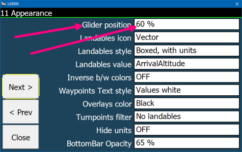
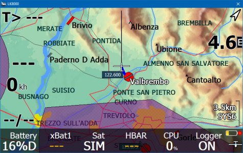
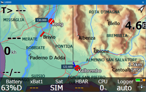
- The images below are taken from an aging flight-computer for gliders, called "LK8000" (intended to run on WinCE devices and early Android phones/tables). This is just a simple illustration (and functional example) of the solution I'm suggesting.
- In the first two images you can see the map setting to place the glider icon at 60% up from the bottom of the screen.
- In the final two images, this setting has been adjusted to 35% and you can see much more of the mountains and river ahead of the aircraft (while remaining at the same zoom level).


Thanks to the Dev Team for your consideration!
--Noel Wade
Seattle, WA
P.S. I just realized there's a much less computationally-expensive and less-clunky way to deal with rendering the offset map center than the methods I mentioned above; my graphics programming skills are rustier than I realized!
Last edited:
