Finding airspace owner/frequency

blw

Member
Joined
Sep 2, 2023
Messages
6
Reaction score
1
I'm just getting started in a trial of your EFB, and I'm totally new to the world of EFB's so have no real experience with any of them. I'm an rusty pilot and paper chart guy. Also, I'm playing with it on the ground (and I realize some things are likely different in flight) so maybe I'm just overlooking the obvious

So far it seems to be a bit clunky trying to find the controlling agency's freq.

a few different scenarios I'm considering:
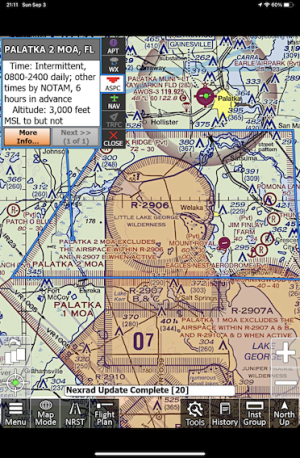
1) when I click on special use, such as a MOA, it does a nice job of highlighting the borders of the airspace, and I readily see the times and altitudes, and the more info expands to show the rest of the info box. It even tells me the controlling agency when I've tried it but does not always list a contact.
a) in the example case I'm looking at right now Palatka 2 MOA in florida, it says controlling agency FAA Jax ARTCC....but does not give me a contact freq.
b) clicking in R-2907A does say frequency 134. Is that supposed to be 134.000?

2) my second scenario: If tooling along VFR not talking with anybody....and decide to pick up flight following. Intuitively , I was thinking that if I click on the map in an area especially with no airport or navaid, OR if I click on my "present position" that it might show me the airspace and list some contact freqs. Is the area controlled by a center or an approach control? and in that area, what is the best contact freq for them? Maybe better even to also highlight the ATC Center's sector geography, so that I can see if I'm getting ready to leave an area, etc....
 
You pose some good questions as they challenge me to explore more of the iFly user interface. Which is a good thing.

1) I don't know that I've seen this behavior but will be on the lookout for it.
a) Pretty sure iFly gets it's info from the sectional data feed that is provided to them. I looked at the chart data for Palatka 2 MOA - it lists exactly the same info as iFly displays when I click on the MOA - no contact freq shown.

1693760611896.png

b) Not sure why iFly doesn't add/include the decimal point after the contact freq.

2)If you want to find freq while tooling along.. touch the screen - on a location that does not have an underlying feature like an airport or fix - until you see the circle of green dots. The menu will give you Options, select Quickview Options, the popup Quickview (the same box/menu/info that pops up when one touches a feature) should have the NAV button highlighted. Select More Options, select Browse Map Legends and there will be a list of Freqs, MOA info etc. Once at that level, one can scroll left/right through the different pages of the Map Legends using the Prev Page/Next Page buttons at the bottom.

Granted not exactly intuitive to find.
 
Yep, I saw that too... so I'd assume it to be whatever sector of Jax center covers that area. Sure would be nice to be a click or two away from that info

and I did find that find a browse map legends button...but I found it in the little button that shows up on the lower left just above the "menu" button. Brings up a sub menu titles Select Map. Really great idea to have that. A feature I struggled with a while back playing with Garmin Pilot.... just wanted to see the legend key, or the list you captured above (MOA list). I was really missing the simplicity of paper. iFly did a great job.

Still, need to find the center freq for that sector if you want to call to see if teh MOA is hot....
 
I supect that the Info box is truncating the info and that, maybe, what you're seeing--differs from what I see on my iPad MIni 6--is only part of what iFly has found.
1693790234403.png
I sent in a screenshot bug report, but it wouldn't do any harm for someone else to send one, too.
 
It is sometimes a two-step process:

1 - click on the SUA and then click on "More Info" to find the controlling agency. The frequency may be found in the "More Info" window (such as for Alert Areas... as an example, check the Alert Area to the east of the Palatka MOA: A-293). MOA's appear to be controlled by ARTCC for the sector... in the "More Info" window, it will name which ARTCC.

2 - I guess since the frequencies for an ARTCC may differ depending on where you are actually flying, click on the airport nearest to you and click on the "Airport Info..." button in the airport pop-up. Scroll down to the "Communications" section and locate "Nearest ATC" and the frequency will be listed. Using the Palatka MOA as an example, if you are flying to the SW of the MOA near OCF (Ocala INTL) the Jacksonville ARTCC frequency is listed as 135.75. However, if you are flying to the NE of the MOA near 28J (Palatka Muni) the Jacksonville ARTCC frequency is listed as 135.45.

It does appear that Restricted Areas are controlled by a mix of controlling agencies... some TRACON and some ARTCC. The ones around the Palatka MOAs list both. In either case, the frequencies for each are sometimes listed. The Restricted areas around the Palatka MOA do list frequencies for areas controlled by TRACONs and ARTCCs. However, the Restricted Areas to the north near 42J (Keystone Heights) don't list any frequencies, whether they are controlled by TRACONs or ARTCCs. I'm not sure what the margin notes of the Sectional covering this part of Florida show for these SUAs. Does AP capture the margin notes for Sectionals and if so, how would we read them? I know that a competitors product does and presents them as "documents" to the user. EDIT: I found kind of a version of sectional margin notes by clicking on the icon above the "Menu" button that looks like some stacked pages and then clicking on "Browse Map Legends...".
 
Last edited:
for item 2. Yes, that is a workaround.....but it's not exactly as useful as clicking the map to see the freq and also to see the geographic boundaries of the sector

Just guessing, but I recon that it might be hard to parse the data for things like the MOA's that don't have the freq published in the map's legend table. I suppose the data needs to be published someplace in order to grab it...but at least if it came up listing the controlling agency and freq for that sector...be it either center or approach...at least you'd have a get to the point quick and easy contact

I downloaded a trial for foreflight onto my daughter's iphone (I don't have an IOS device myself) and see that FF does this to highlight center sectors....
 
This thread really interests me, especially because I've looked for a frequency in flight a good many times--such as when flying a seaplane from Virginia to Winterhaven, FL. and suddenly realizing when approaching Lake George that I didn't know whether Palatka was hot and was unable to remember the Overlord frequency. Phew! You'd think I would have planned ahead.

iFly helps with problems like this: Select the little three-maps button above the little green dot of the present-location button and then if you happen to be at the right altitude you can select "Browse Map Legends." That opens up a long list of places to look, and one of them probably has the freq you need.

But, really, who can do that while cruising south and getting ever closer to that ungodly-tall antenna tower that tops out at 1549 MSL and you want to skim along Lake George at, say, 10 feet?!

Of course if you were on Flight Following you could just try ATC--but what fun is that? And anyway, it's a bit late to think about what's hot and what's not by that time. So it would be delightful if iFly could anticipate your situation and pop the freq up as soon as you get close to a Restricted Area or an MOA or an Alert. I'd love that!

AI to the rescue!
 
I have noticed that iFly truncates the frequencies. I looked and overlord is 134.00. The more info shows 134 Without knowing the actual freq, it would have me guessing if something was cut off as opposed to the actual freq.
 
Back
Top