historical flight tracking? Setting Time zone?

GyroGypsy

Member
Joined
Apr 23, 2023
Messages
12
Reaction score
4
Q1. Does the 740 save all previous flight history, track and altitude? Where is this displayed? Is there a current elapsed flight timer?

Q2. I live in Colorado, now on MST. Setting MST either w/w-out DST keeps showing the same time, which is one hour early. I set to PST for now.
 
Sorry Mdreger, but your reply makes no sense to me. Can you provide explicit details, or give links to documentation or videos that would explain better? Thank you.

What about Q2?
 
Q1: MDreger was informing you where the log files are stored on the 740's removable SD card. You could plug that into an SD card reader on a desktop or laptop PC or Mac, for instance, and pull all the flight log files off and upload them to your favorite flight path viewer app or website. But if you mean from within iFly, you can see the current flight trail by going to Menu > Setup > Map Settings, and then check the box for "Show Flight Trails", or you can view past flight trails by going to History > Show Past Flight Trail..., and then selecting the flight you want to view.

I don't think viewing within iFly shows you the altitudes you were at during the flight, just the ground track. Getting the logs from the SD card and moving them to another app that specializes in viewing flights is better for that.

Re: Elapsed flight timer, yes. It's part of the standard instrument groupings, in the upper-right corner of the screen, labeled "Flt Duration". You can customize the built-in instrument layouts (or create new ones from scratch) to move it elsewhere if you prefer.

Re: Q2, I don't know. I'll see if I can dig out my old 720 and see if it's similar enough to compare, but hopefully another 740 user who lives out west can pipe up.
 
Hi Cobra, Thanks for the help. I will look into these flight path options. What do you suggest as a "favorite flight path viewer"?

I will find and add the Elapsed timer. Thanks again.

I am extra proficient on most computer issues, but the time zone thing has me baffled.
 
Last edited:
An easy way to get what you want is to use the MyFlightBook app. It tracks your flight path, altitude, and flight time. When you look at it on the website it displays it all nicely in graphs and on a map (click on the paperclip icon). Of course, its main function is to serve as a flight log, which is the main reason I use it. But it's fun and/or instructive sometimes to look at the flight info.
 
Hi Cobra, Thanks for the help. I will look into these flight path options. What do you suggest as a "favorite flight path viewer"?
Sorry, I really don't have one. If I'm curious about my path, I sometimes look it up on flightaware.com, or pull up a trail in iFly. It's not important to me to see the altitude, so I've never really looked for an app that shows that. I know they're out there, though...maybe another user will have a good suggestion, or you could try Googling "best gpx viewer" or variations on that theme.

I don't think iFly actually outputs .gpx files (I forget what format they use), but most sites that can consume .gpx files can also consume whatever format iFly uses, too.
 
Hook, This looks like a nice app. However I am currently using the Gyropedia.com app which integrates into gyrocopter training. I will try both for a while. Meanwhile I just now found "Gyropilots 3D Flight Recorder" which integrates into Gyropedia, and runs on Android. Maybe a perfect solution.

One issue both iFlyGPS and MyFlightBook share is that zero airspeed means "landed". One maneuver required for achieving gyro certification, and I find enjoyable (as perhaps a fixed wing pilot might enjoy stalls!) is a "vertical descent". This is when throttle to idle, back pressure as required to achieve zero forward airspeed, The unpowered rotor has a slight decrease, and one descends in perfect control at about 700 fpm. Release back pressure at about 300-500 AGL, recovering to a forward airspeed of 50-60 kts while in a dive, then a gradual flare to normal landing. No power is added. This maneuver is great to practice with the runway numbers visible just under the nose, and plan a idle power smooth touchdown on the 1000 ft marker.
 
MyFlightbook can actually set the speed which corresponds to "start/end" of flight, but as you point out, there is no speed you can select that can account for an airborne vehicle that has no groundspeed.

In that case, under "Profile", MyFlightbook allows you to uncheck the "Autodetect Takeoffs and Landings" feature, so that you then must manually indicate your flight start and stop times.
 
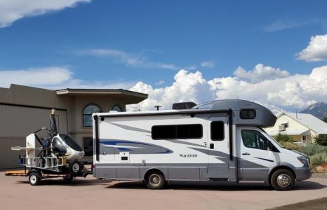
Cobra, I went through the MyFlightBook setup, and set my "start" at 20 kts(?). I suspect the new-found, but untried, "Gyropilots 3D Flight Recorder" will be my go-to app. I want to easily show 500 ft separation "just in case". The Trent Palmer case with recent FAA decision has me much more worried now. I like flying low and slow, especially in spite of any gusty crosswinds, and a gyro is many times less expensive and lower maintenance than any true helicopter. Besides, they are shorter and easily towed. This older model fits on a 12 ft open trailer, together with fuel, and rotor hoist/ladders for rotor attachment.

Gyro Gypsy 2.jpg
 
GyroGypsy,

That is a really cool setup you have! Looks like a lot of fun! The vertical descent exercise sounds like a lot of fun and must be really rewarding when you can hit the 1,000' mark and roll out in less than 100'.
 
Back
Top