- Joined
- Dec 5, 2023
- Messages
- 115
- Reaction score
- 25
This may be user error...
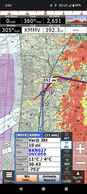
You can see in the below screen shot that KMMV is overcast at 5000'. Since NEXRAD is enabled, why doesn't it show this cloud layer? As a VFR pilot I am looking for a visual of all clouds on my routing. For example, in this situation I would be above 5k' when inroute to this destination so would be looking for a place to drop below. Is there a way to get this data from iFly or should I be looking somewhere else?

You can see in the below screen shot that KMMV is overcast at 5000'. Since NEXRAD is enabled, why doesn't it show this cloud layer? As a VFR pilot I am looking for a visual of all clouds on my routing. For example, in this situation I would be above 5k' when inroute to this destination so would be looking for a place to drop below. Is there a way to get this data from iFly or should I be looking somewhere else?


