- Joined
- Apr 13, 2023
- Messages
- 543
- Reaction score
- 96
Here's another reason for iFly EFB to use the device's native copy function:
It's easy to find the gps coordinates of any location--just tap on it. It's a great feature of iFly. But then what?!
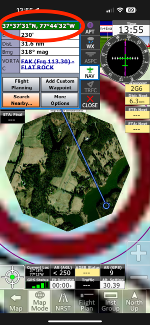
For example, 1VA0, Sabot Airpark has a 2400 ft grass runway, with a lake parallel to it. iFly's RealView shows part of the lake, but not enough to decide about landing on it, and the resolution is just so-so anyway. I want to open the location in GoogleMaps to get a better look. The coordinates appear at the top of the RealView window, but--arrgh!--I'll have to enter them* manually into GoogleMaps.

If iFly could COPY the coordinates, I could just paste 'em in.
Even better would be for iFly to provide a button to open GoogleMaps to that location.
____________________
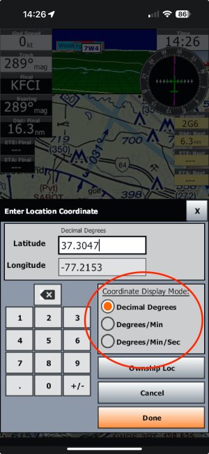
* What's with the ancient degrees-minutes-seconds notation, anyway? This is the 21st century. We use digits now. Yes, I KNOW iFly provides the choice of modern and ancient-mariner coordinates. But it doesn't need to default to d-m-s format, especially not when the user has already selected Decimal Degrees.

Yes yes, I also know that the printed Sectional charts use DMS notation. --What printed charts??
It's easy to find the gps coordinates of any location--just tap on it. It's a great feature of iFly. But then what?!
For example, 1VA0, Sabot Airpark has a 2400 ft grass runway, with a lake parallel to it. iFly's RealView shows part of the lake, but not enough to decide about landing on it, and the resolution is just so-so anyway. I want to open the location in GoogleMaps to get a better look. The coordinates appear at the top of the RealView window, but--arrgh!--I'll have to enter them* manually into GoogleMaps.

If iFly could COPY the coordinates, I could just paste 'em in.
Even better would be for iFly to provide a button to open GoogleMaps to that location.
____________________
* What's with the ancient degrees-minutes-seconds notation, anyway? This is the 21st century. We use digits now. Yes, I KNOW iFly provides the choice of modern and ancient-mariner coordinates. But it doesn't need to default to d-m-s format, especially not when the user has already selected Decimal Degrees.

Yes yes, I also know that the printed Sectional charts use DMS notation. --What printed charts??
