You are using an out of date browser. It may not display this or other websites correctly.
You should upgrade or use an alternative browser.
You should upgrade or use an alternative browser.
Downloading historical tracks
- Thread starter GyroGypsy
- Start date
If and where you can find them probably changes depending on what device you are using. You might specify what device you're running iFly on. Include as much information as you can regarding the device name, model, series, version, etc.
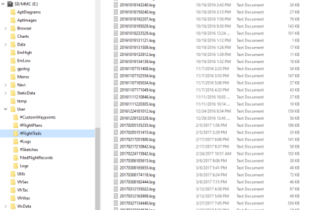
In the Windows version I believe they can be found in the #Flight Trails folder.

Still Windows, these should be the files you're looking for. Looks like the file names are, at least partly, the date and time of the flight.

In the Windows version I believe they can be found in the #Flight Trails folder.

Still Windows, these should be the files you're looking for. Looks like the file names are, at least partly, the date and time of the flight.

Looks pretty much the same. Open the SD card in File Manager, or whatever it's called now, and it looks almost exactly the same. You can open and read the .log files in Notepad. If you search elsewhere in this forum I'm pretty sure that people have listed at least one, probably more, sites that can read and display the flight tracks, some include altitude depictions as well.


