Feature: Display/Broadcast lat/long in an emergency

TSchnell

Moderator
Staff member
Official iFly Beta User
Joined
Apr 19, 2023
Messages
12
Reaction score
5
Feature: Display/broadcast lat/long in an emergency
Description: Would allow pilots to display and broadcast lat/lon data in the event of an emergency.
Edit: You can up/down vote on the right side of posts.
 
Last edited:
As for displaying your position, simply go to Setup Customize Instrument layout and ADD the Current Position instrument to your layout. Problem solved, you can broadcast it w MayDay call :)
 
Personally, I have that instrument on my display already. What I would like to see is the lat/long being displayed (along with nearby airports) when I press the emergency red triangle in the NRST menu so I don't have to remember to first make the radio call while in the normal map display (where I would see the Current Position instrument) and *then* go to NRST. In fact, I think lat/long should probably be shown in the base NRST display too, as well as when you hit the emergency triangle in that display.
 
That is a good idea! FWIW, I also asked them to make an Instrument Option for Current Position that shows Decimal Degrees vs DMS. More GPS and mapping software use that now, and converting it mentally isn't as easy as it looks.
 
That is a good idea! FWIW, I also asked them to make an Instrument Option for Current Position that shows Decimal Degrees vs DMS. More GPS and mapping software use that now, and converting it mentally isn't as easy as it looks.
Yes, I did that too, last fall. It also should be copyable, for many situations where you'd like to put the coords into a text message or email or log. And definitely in decimal format. This is the 21st century, after all.

By the way, Apple says that the newer iPhones can do commo via satellites when cell service is unavailable. I haven't tried it yet--but it would be absolutely great to paste the coords into a satellite message.
 
I'd like to see maybe a toggle between Decimal Degrees and DMS... Isn't Google maps in D/D?
 
I'd like to see maybe a toggle between Decimal Degrees and DMS... Isn't Google maps in D/D?
I think almost everybody has gone to decimal degrees now. It may not be consonant with the number of minutes in an hour or hours in a day, so that history is lost. But it's sooo much simpler!
 
I think almost everybody has gone to decimal degrees now. It may not be consonant with the number of minutes in an hour or hours in a day, so that history is lost. But it's sooo much simpler!
I like where this is ending up. I think we can satisfy most of the needs with a couple easy changes:
1. Change "Current Loc" over to D/D.. How many decimal digits? (2 or 3)? (2 digits provides about half-mile precision)
(Should we provide a way for users to love DMS to change it back? as instrument option? Or we can wait and listen for pains, if enough complain, then we remedy it then..)

2. NRST form should show Current Location on the screen D/D Format


If we did these two things, how close are we to satisfying the needs for this?
 
It looks to me like the Current Location instrument can support four decimal digits (e.g. 122.1234). You display five digits in the larger window that comes up if you tap on the instrument. I would keep that, as well as displaying it in DDMMSS in that larger window (as you do now).

For consistency, if you can fit it, why not go with four digits in NRST. Or at least three. Just for comparison, Google Maps gives lat-lon to five digits.

I think you should make it an option in the Units of Measure menu as to whether it's in DDMMSS or decimal (which should probably be the default).
We aim for fewer digits, so you have less to "announce over the radio as you are crash landing". If we provide 5-digits, the pilots may feel obligated to say 5 decimal digits.

2 digits, when rounded specifies about 4000 ft intervals, which means +/- 2000' accuracy... For finding someone, this seems to be plenty of resolution, especially since you aren't going to touch down then... so you're not going to be within 2000' of where you made your announcement -- so what good is more than 2 decimal digits for emergency?

3 digits, when rounded specifies 400 ft intervals, which means +/- 200' accuracy. Given that you fly this far in a few seconds - there seems to be no reason at all to show more. If you tap the instrument, we can show the 5 digits. (2' accuracy!)....

I'm guessing 3-decimal digits is probably the best precision for the "Current Loc" readout. And 5-digits if you tap it for the bigger form.

So a readout would be like: "39.481/-85.213"

The shorter the text, the bigger the font we can use. Should we include the suffixes "N/S" and "E/W"? Or is the Lat/Lon order understood/intuitive? (and if it's not, tap it, and the big form will be explicit to clear up any confusion)
 
Good stuff. Well, by your reasoning, I would vote for 2 (or maybe 3 if they fit) digits plus the cardinal position, and leave out any negative sign.. E.g. 39.48N/85.21W or N39.48/W85.21. Two digits seems reasonable for this situation, but people might feel that 3 seems better though you say it's overkill. My reasoning for the cardinal position is that in an emergency a pilot may skip over announcing the minus sign for longitude. But is that lack of clarity really likely to send rescue to the wrong half of the planet? No. I'm fine with whatever you do.
 
Last edited:
We aim for fewer digits, so you have less to "announce over the radio as you are crash landing". If we provide 5-digits, the pilots may feel obligated to say 5 decimal digits.

2 digits, when rounded specifies about 4000 ft intervals, which means +/- 2000' accuracy... For finding someone, this seems to be plenty of resolution, especially since you aren't going to touch down then... so you're not going to be within 2000' of where you made your announcement -- so what good is more than 2 decimal digits for emergency?

3 digits, when rounded specifies 400 ft intervals, which means +/- 200' accuracy. Given that you fly this far in a few seconds - there seems to be no reason at all to show more. If you tap the instrument, we can show the 5 digits. (2' accuracy!)....

I'm guessing 3-decimal digits is probably the best precision for the "Current Loc" readout. And 5-digits if you tap it for the bigger form.

So a readout would be like: "39.481/-85.213"

The shorter the text, the bigger the font we can use. Should we include the suffixes "N/S" and "E/W"? Or is the Lat/Lon order understood/intuitive? (and if it's not, tap it, and the big form will be explicit to clear up any confusion)
Brian, this is a case where less is not more. If a pilot about to crash reads off 5 numbers by 5 numbers instead of 3 by 3 --so what?

I don't like the forward-slash in your sample format, "39.481/-85.213". The slash character usually means OR, not space. I'd go for "39.481 -85.213" or "39.481N 85.323W" instead.

As for the size of the numbers, I don't see how you'll get bigger characters by reducing the number of decimal places. They're still going to be the same height as they are now unless you widen the box and put both lat and lon on the same line. Go to decimals and you get rid of the really tiny º and ' characters.
 
39.481N, 85.323W is pretty standard notation, I think. That's what I'd recommend. I think 3 decimals is good.

If iFly's going to use decimal degrees here, I think it should use decimal degrees elsewhere, or at least have the option to select that format (just like choosing between mi/km, degF/degC, mph vs knots, etc.).

I would suggest an option for three formats: Deg/Min/Sec, Deg/Decimal Minutes, and Decimal Degrees.
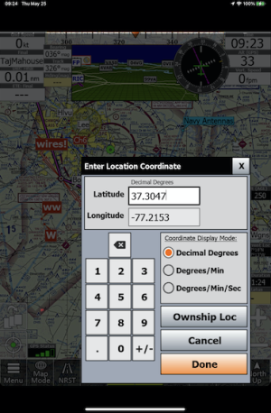
Agreed. Default to decimal degrees. iFly already allows that:
1685021227696.png
...but it's not the default.
 
Hah--thanks, for that reminder, Don!

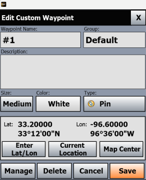
Unfortunately, while iFly allows all three formats for input, once the waypoint is created iFly loses the ability to display its location in that middle (Deg/Min) format.

I recently went through the process of creating some custom waypoints on both iFly and my panel-mounted GPS navigator, and I recall having to convert in my head between (Deg / Min / Sec) and (Deg / Decimal Min). My panel navigator only supports input using Deg/Min, but that was the one format iFly wouldn't show me (see below).

Fortunately, it was easy for me to do the conversion from Min/Sec to decimal minutes in my head, but that's maybe not true for everybody.

1685035308721.png

I guess I was hoping that iFly could be configured via user settings to globally/consistently use one format everywhere, or else have all three formats always visible everywhere, to avoid the issue I had.
 
Last edited:
Hah--thanks, for that reminder, Don!

Unfortunately, while iFly allows all three formats for input, once the waypoint is created iFly loses the ability to display its location in that middle (Deg/Min) format.

I recently went through the process of creating some custom waypoints on both iFly and my panel-mounted GPS navigator, and I recall having to convert in my head between (Deg / Min / Sec) and (Deg / Decimal Min). My panel navigator only supports input using Deg/Min, but that was the one format iFly wouldn't show me (see below).

Fortunately, it was easy for me to do the conversion from Min/Sec to decimal minutes in my head, but that's maybe not true for everybody.

View attachment 168

I guess I was hoping that iFly could be configured via user settings to globally/consistently use one format everywhere, or else have all three formats always visible everywhere, to avoid the issue I had.
Cobra, I think iFly should use decimal degrees but automatically convert to and from the other two formats, as well. Sectionals still use d-g-m, so we can't just ignore it. The user shouldn't have to do head math to know where he/she /they/I/we/you is and or are. (Mental math is fun if you don't have to do it. I once watched a Scottish maths teacher adding columns of two-digit numbers--76+41+97+88, etc--by the line, not the column, and discovered that it was easy, fast, and fun. When she demonstrated three-digit numbers and then four-digits, though, I got a bit overwhelmed. Found I could do it, but it took some concentration!)
 
Cobra, I think iFly should use decimal degrees but automatically convert to and from the other two formats, as well.
Hm. I don't know that I want to force iFly to have a preferred lat/lon notation. I think that should be left to the user, which is why I suggested either a user setting to change the degrees format, or else present all three formats wherever they're displayed.

The one exception is how to present lat/lon in an emergency, which was the original focus of this post. In that specific case, I agree that only presenting decimal degrees (to 3 decimal places) is appropriate--just give the user a short series of numbers they could read off to ATC.
 
Last edited:
3 ok, I'd think 2 was enough. D.ddd format it won't be long til they convert sectionals too IMHO
 
Thanks for all the feedback. I'm currently leaning towards the following resolution proposal:

1. Favor showing just 3-decimals on the instrument, even if overkill, gives pilot a better feeling.

2. Add setting to Units-of-Measure for preferred display format. This will then apply to the "current Loc" instrument, as well as the Flight Plan Lat/Lon points, and maybe a few other places.

3. Use comma(,) to separate the two, not slash (/).

4. NRST form will show this on screen, in the preferred format.


Keep in mind that my proposals are rarely accepted as is -- this is simply what I'm suggesting to "take to the table" for Walter's review.
 
Brian, I'm for something like simultaneous translation--so that iFly will accept any of the three formats anytime anywhere and then convert them to the user's preference. That probably ought to include mixing them up: digital degrees of latitude, for example, and d-m-s for longitude.
 
Back
Top