Indicated Altitude display

N714AJ

Member
Joined
Apr 21, 2023
Messages
6
Reaction score
6
Location
Carlisle, PA, USA
REF: Altitude of Traffic Display (full altitude vs. partial altitude readings)

Greetings,

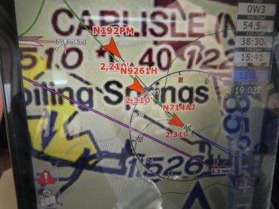
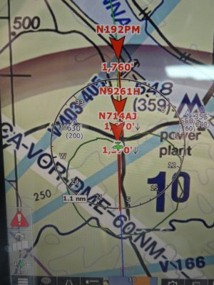
I recently updated by IFly EFB and noticed that the altitudes of all my targets truncated the altitude to the first 2-3 digits.

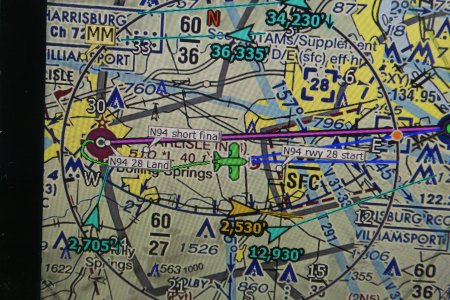
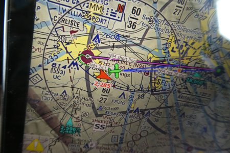
For example, when traffic formerly read "2,300" it now reads just "23."

I would like to GO BACK to the way it was as I fly low (about 1500 AGL for the most part), and have crop-dusters and helicopters below me and much traffic just above me -- so I appreciate the FULL altitude read out on my screen.

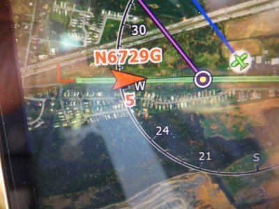
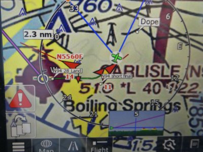
Is it still possible to have that displayed on my screen? See below for the way I prefer to have the traffic display on my screen.

Thank you in advance for any assistance! I did try to adjust it using the options offered, but so far no luck on my part.

Mike (long time user and loyal customer!)
N714AJ
N94 Carlisle, PA
 

Attachments

  • P1080549.JPG
    P1080549.JPG
    2.7 MB · Views: 10
  • P1080547.JPG
    P1080547.JPG
    1.7 MB · Views: 10
I tried turning OFF relative altitude and tried both INDICATED and GPS altitudes but still I cannot get the FULL READOUT of traffic altitude around me...so, instead of getting 1,500, I get 15.

How is this a flight safety problem for me?

I fly LOW, around 1,000 to 1,500 feet AGL and I have MUCH traffic under me with crop dusters and helos...I would strongly prefer the FULL readout.

I cannot get it to go back to the way I liked it and worked for me to avoid traffic as I fly in a HIGH traffic area.

Thanks - Mike

Photo 1 and 2 = what I want to see

Photo 3 and 4 = what I am getting and do NOT prefer


Please help - thank you.

Mike
 

Attachments

  • P1460377.JPG
    P1460377.JPG
    1.6 MB · Views: 11
  • P1460425.JPG
    P1460425.JPG
    1.7 MB · Views: 11
  • P1530012.JPG
    P1530012.JPG
    1.3 MB · Views: 10
  • P1530025.JPG
    P1530025.JPG
    1.4 MB · Views: 10
Last edited:
If you want a definitive answer, I'd suggest calling Adventure Pilot's Support line during normal business hours.

From: https://adventurepilot.community.fo...-asking-questions-please-help-us-help-you.27/
Welcome to the iFly EFB Support subforum! This is primarily a peer-to-peer, users helping users environment, not an official Adventure Pilot support channel. In general, folks here will try their best to get your problem solved, but please understand that this is a volunteer effort.

Note: If you're wanting to ask for a new feature or a change in how iFly EFB works, please post that in the "Feature Requests" forum.

If you can't get your issue resolved here, there are more support options available at the iFly EFB website: https://www.iflyefb.com/Support/Get-Help
 
I'm unable to reproduce this issue, I've asked Brian to chime in to see if he has any thoughts
-W
 
This was my doing. During testing of heavy traffic ADSB replays, noticing the extra text on the screen. And noticed the inconsistency between relative altitude being in terms of "FL", while absolute altitude was raw 'feet'.

Since ADSB traffic updating typically has delay, and there is also issues of precision of altitudes, we're dealing with a precision of about +/-50', thus the standard for Aviation to specify altitudes in terms of 'FL' (flight levels) - so rather than showing "12,389'" now we just show "124" and saves screen space/clutter, while also being consistent with our use of FL for Relative altitudes.

It is certainly not hard for me to add in the option of showing the longer form readout, if Walter says to do this (would just need an option provided to you when you disable 'Relative Altitude' - it will ask you then). Our current setting is two-state - "Absolute Altitude = (true/false)", and just would change it to 3-state - "Relative, Absolute FL, Absolute Feet". So an easy change.

We try not to add less-meaningful flexibilities (i.e. more user options, which also add confusion/complexity).

===
For these read outs, I was thinking of adding a tweak here, of "biasing the rounding to FL" TOWARDS ownship altitude, for safety safe.

So if you are flying at 800' and another aircraft if flying at 974', I'd round DOWN to showing FL "9". And likewise, if they were flying at 526', I'd round up to FL "6". This would just be a "25'" bias TOWARDS ownship, so that "525'" still rounds down to "FL 5", but "526'" rounds up to "FL 6".

Something like that -- so that we err on the side of safety without skewing the raw data too much.

Personally, I think shorter displays are easier for the mind to digest, especially since in this case the "FL" concept is industry standard, and our 'relative altitudes' were already in terms of "FL".

===
I get that change most often delivers a negative shock. I'd like for you to put a bit more consideration into this, and I'd love to hear some opinions of others too - we're weighing various concerns here (simplicity vs. complexity, screen clutter, consistency, and user-preference).
 
Brian, thanks for the explanation, but my vote is strongly for giving the pilot the option to display the target altitude in feet or in FL's.

And here's my reason: we don't fly at FL's - we fly at altitudes in feet. My altimeter shows us how high we are in feet and our current altitude is firmly etched in our brains. It takes a bit of mental processing to convert say, 10500 to 105, then for the brain to remember that 105 is actually 10500 feet.

On the same note, for us it's much more useful to see a targets reported altitude, not the offset. For nearby targets, we watch the reported altitude for changes in the height of the target which for some reason just makes sense to us.

Please give us back the feature we had before this update.
 
Last edited:
I'll be reverting this back to how it was -- showing "feet MSL" for the absolute traffic altitude. If someone then gripes, "hey where is my FL??" - then we can consider providing the flexible option of choosing the units. This will be changed back for the next beta, coming probably by end of this week.
 
Gents,

First off, THANK YOU to iFly - Walter and Brian - for a great product and for taking the time and effort to listen to our concerns. Deeply appreciated and the MAIN REASON I am a lifelong subscriber to this particular EFB.

Years ago, iFly abbreviated "Distance to go" to the nearest mile and I asked that you please keep it the way it was, so we went back to "11.6 vs. 12 miles to go" for instance. This was HUGELY helpful to folks like us who fly low, slow and with others in caravans so we can do rejoins with a lot more precision. It also helped immeasurably with finding small grass fields in the middle of nowhere that are not clearly evident - places small aircraft like ours frequent - so thanks again for making that change.

This is a similar request. Many of us fly low and slow and not in the FL altitudes, and we fly in congested places where aircraft fly very low. We have a lot of helicopters, crop-dusters and now some DRONES equipped (or soon will be) with transponders and ADSB out. Trying to figure out if one of these aircraft is flying 7500 vs 75 feet is a safety of flight issue here where I fly. I know this sounds unusual, but the future of ADSB portends ALL things that fly eventually become equipped, so vehicles flying very low and reporting is increasingly ubiquitous.

If you are taking inputs, I would prefer to see us have the option to go back to the exact readouts. Not rounded up or down, the exact readout.

Brian, I see your logic and respect why you made the change initially. I also understand your preference in rounding up. We just have an alternate preference. I know you cannot please everyone, but if you can provide us an option, my vote would be to allow the full readout and to the exact foot.

Again, THANK YOU for even entertaining this conversation.

Keep up the great work.

Regards, Mike Marra
N714AJ
 
If you are taking inputs, I would prefer to see us have the option to go back to the exact readouts. Not rounded up or down, the exact readout.
The engineer in me recoils at the idea of "exact" readouts, because it implies a level of precision that simply does not exist. Many ADSB-out devices are only outputting altitude to the nearest 100'. Even for those that are outputting to the nearest foot, by the time that data gets to you it could be off by tens of feet. And even if flying straight and level, the reference source between your two planes could potentially be different--barometric references could have small differences due to variance in pressure sensor accuracy. Even if using GPS, the altitude fix can be "noisy". You cannot and should not ever be believing those last couple of digits because they will be wrong.

A secondary reason for disliking an "exact" altitude readout is that long strings of digits can be confused for aircraft registration numbers at a glance. Sometimes I'll hear "Cherokee 321 3 miles east of the field" or somesuch and I'll glance down to see if I see a target ending in 321. I don't want to be fooled by a meaninglessly-"precise" altitude that happens to end in 321 (or something close enough that my brain reads it as a match) in that second I glanced down.

Those arguments address the question of showing 319 vs. 300 or 2179 vs 2200 on the screen.

As for the question of showing an extra two digits (either 2179 or 2200 vs a truncated 22), I would prefer altitude separations to be presented as only two (or three, if you've told iFly to show you *all* traffic regardless of vertical separation distance) digits. It's easy for me to remember that if I see "3", that's a target within 300', not 3', because I know a precision of 3' is ridiculous. And I'd rather see more of the map than have a not-needed extra couple of digits taking up space.
 
Last edited:
Yes! All good and why it should perhaps be an optional setting either way as we both have divergent preferences.

So much of how we fly and what we want on the screen is based on preferences...often times people get in debates when there is no absolutely "correct" answer as our preference for informing the screen differ significantly.

Again, we appreciate iFly taking the time to listen and perhaps consider our preferences.i really LOVE the iFly EFB BECAUSE you do have so many options to show (or not show) information that assists us in the many DIFFERENT ways we fly....

Thanks everyone!
 
My 2cents: I like the idea of something configurable by the user on how I want to see the altitude information about the target (full "precise" or rounded & truncated altitude, actual MSL altitude or in relation to my altitude). If the "precise" data is there let the user decide what they want to see. To Cobra's point about seeing more of the map: all I want to see about an ADS-b traffic target is its altitude (or altidude in relation to me), horizontal direction of travel and speed (the line coming from nose of the icon and length to provide a representation of the speed) and the vertical direction of travel (climbing or descending represented with an up or down arrow). I can tap the aircraft icon to get any additional information that might interest me: tail number, make/model of aircraft, etc...).
 
I fly in the same area as Mike and at similar altitudes, I use Relative Altitude so I know to look up or down without thinking about my altitude. I'm fine with rounding given all the variables in altimetry, maneuvering, display lag and screen congestion.

Since I do aero there is nothing loose in my cockpit and my phone is mounted and on charge and I have begun using it as a dedicated HSI and Traffic Radar display, it sends alerts to my headset via Bluetooth. My primary nav display is a new X7 tablet that is readily readable at 60%.
 
Last edited:
Back
Top