MUI

Ray93J

Active member
Official iFly Beta User
Joined
Apr 20, 2023
Messages
36
Reaction score
5
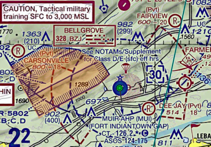
There is a military airport at Fort Indiantown Gap PA with the id MUI. It has class D airspace with a CT frequency. If you tap on the airport, no airport information comes up. You can find airport information on Air Nav. If you put MUI in a flight plan, it is not recognized as an airport.

All the airport info including IA procedures is available on AOPA airport finder.

Airport is located near the Harrisburg Intl (MDT).

Is there an explanation for this?
 
Last edited:
IDK, maybe because it's a military heliport, and civilians aren't allowed to land there without prior permission?

1745020894443.png

It is curious that AOPA, and Airnave have the info. How about ForeFlight or others?
 
I will have to check with my friend that uses FF. I am sure it is some kind of data availability problem. I don’t know about other military installations around the county. Maybe others will jump in.
 
Hi All,

The reason it does not show up: Heliports are filtered whenever the selected aircraft profile is "Fixed-Wing" and not "Helicopter."

If you change your Aircraft Class to Helicopter (Menu > Setup > Aircraft Profile > Edit) then you should be able to see the details about the heliport. However, the METAR is still available when the WX tab is selected on the QuickView pop up.
 
OK, that woks. But this is not convenient, requiring changing my aircraft profile to a helicopter to view the airport / heliport data. Maybe MUI is unique with a 4000 ft runway. PA National Guard operates C-130’s from there. I don’t know how many locations are like this.

I believe the better solution would allow you to show either or both. I don’t know why this option is not in the map menu vs aircraft menu. The advantage of an EFB is to be able to tap on a location and bring up all data in a readable form.

I will admit, I am in the area of MUI frequently and I just noticed it this weekend., I will have my FF friend show me how the selection works.
 
Aside from the fact that it's a military facility and not open to the general public anyway, the Chart Supplement also clearly marks it as a heliport and not for fixed-wing use:
1745412541630.png

What information are you wanting iFly to provide you, and when would you use that information?

This seems like an edge case to me--how many heliports happen to have a 4000' runway? Personally, I am happy that iFly filters out heliports as the dozen or so around me would just be an annoyance to routinely filter through.
 
It would be nice to get all the info about this airport with a single tap, just like the others. Com frequency to monitor while in the area, etc. I am familiar with the operations there, rotor, fixed wing and UAV all fly from there. Hint, zFF does it. With recent announcements, iFly maybe getting more customers, I hope.
 
Back
Top