Print Flight Plan

Don Maxwell

Moderator
Official iFly Beta User
Joined
Apr 13, 2023
Messages
371
Reaction score
59
One of my favorite features of the lovely art deco experimental beta version of EFB was the ability to print a flight plan. It appeared unannounced in one of the last updates. It was an especially nice surprise because wireless printing was essentially impossible from the iFly portables. But it's simple from most recent tablets and phones.

I don't remember exactly what the steps were to make it print, but it was quick and easy within Flight Plan, and it made my wife and me very happy. She's forever asking for my flight plan when I fly someplace without her, and that printout was exactly what she wanted. It was nothing fancy, as I recall--just an uncluttered printout of what you see in "Flight Plan," with heading, distance, destination, and ETE (or ETA?) and the names of any waypoints along the way. I liked it, too because it was a paper backup of the flight plan, with enough white space for me to make notes. It had all of the info a pilot needs, but it was formatted in a way that my wife, a non-pilot, could grasp immediately.

I seem to recall that there was also a simplified map of the trip, a schematic; but that could be wishful thinking.

If you'd like an easy way to print iFly flight plans wirelessly, too, click on the "upvote" arrow (a chevron).
 
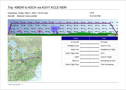
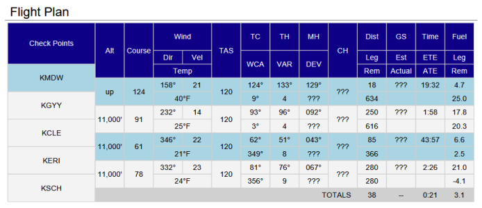
As it happens, I still have iFly EFB on my iPad, so I made up a flight plan from MDW to SCH, and printed out the nav log.

I've attached the .pdf, if anyone wants to see what it looks like. As with most .pdf's you can specify which pages you want to print.

Edit: .pdf, and zipped .pdf both too large to upload. I'll try screenshots.

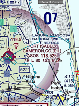
1683331536980.png

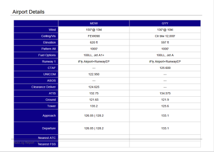
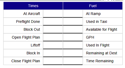
1683331571447.png

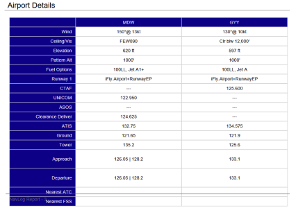
There's Airport details for each airport waypoint I had.
1683331655138.png

Then seven pages of NOTAM's
1683331749093.png
 
Last edited:
Thanks for sharing that, @MDreger . I never noticed any of that when I was using that version of EFB.

So I'm curious: Which of those pages were useful for your wife, @Don Maxwell ? (Per your comments on a thread elsewhere.)
 
Last edited:
Woo hoo! That's even better than I remembered. Thank you!
 
Thanks for sharing that, @MDreger . I never noticed any of that when I was using that version of EFB.

So I'm curious: Which of those pages were useful for your wife, @Don Maxwell ? (Per your comments on a thread elsewhere.)
She only saw one printout, Cobra. Then that EFB experiment ended before I could print out another. As I recall, she liked the map, the checkpoints, the wind (she worries a lot about wind), the distance, and the time. The rest didn't interest her. But I imagine that she would tune into that stuff if she saw more of these printouts. On the other hand, if it were a Real Plan plan, she might be overwhelmed by all the temporary waypoints there would be--just coordinates without names. I think the format worked well for her. The map made the course seem real, not just inexplicable gook. And the list of checkpoints just below it was obviously related to the map and to geography. The distances and times were probably easy enough for her to pick out, and they evidently made sense to her. The stuff in the middle was probably just static to her--certainly TC, TH, and MH are gobble gobble. Also, the plan I printed for her had only three checkpoints--departure, arrival, and one in between--so it was simple.

I think of one thing I'd like added: a small schematic diagram of each airport--just a line for each runway, and the essential radio frequencies, especially for the weather and tower or CTAF. That's the info I still draw out for myself for situational awareness and in case the avionics go poof.
 
I'm just looking at that printed FP page and thinking, "If the screenshot had too much gobbledegook on it, how is this one better?" 🤷🏻‍♂️

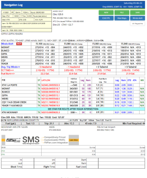
If I print anything out when I fly, it's this. I'm sure it wouldn't be helpful for your wife, but as a pilot, I don't see anything in MDreger's 10 pages that I wish I had that isn't on this single page, and when I print "2 sheets to a page", it comes out perfectly sized for a kneepad (I can fit four flights on a single piece of paper):
1683373058830.png
 
Last edited:
I'm just looking at that printed FP page and thinking, "If the screenshot had too much gobbledegook on it, how is this one better?" 🤷🏻‍♂️

If I print anything out when I fly, it's this. I'm sure it wouldn't be helpful for your wife, but as a pilot, I don't see anything in MDreger's 10 pages that I wish I had that isn't on this single page, and when I print "2 sheets to a page", it comes out perfectly sized for a kneepad (I can fit four flights on a single piece of paper):
View attachment 83
Zowie! Cobra, I've just glowered at your printout for a long time--maybe a minute or two so far--without yet getting oriented to it. It's soooo dense! Where to start?! (That's a rhetorical question only--because right now I don't want to be given a key to unlock it.)

MDreger's early-EFB printout, on the other hand, is if anything too easy. It begins with pictures and then goes on to add text to describe the pictures and apply them to flying an aircraft through the space they depict.

I can't think of two more different descriptions--that is, logs, or more accurately, predictions--of flying from A to B.

My feeling is that for yours, a pilot would probably want considerable experience in flying IFR before starting the engine for this trip. MDreger's pilot can be a beginner on a discovery flight or at any other experience level.

You pilot is not likely to be navigating by pilotage. MDreger's can do it either way.

That's not to say I think printing out seven pages of NOTAMS is sensible. There's definitely need for a STOP THAT!!! switch. There's plenty of room for improvement in that art deco EFB's flight plan and printout.

By analogy, what we have here is glass panel flying versus art deco's Minimum Equipment List flying.

I have to stop here and talk with a neighbor and then go flying (without filing a flight plan). But I'm going to post this much now, just so you won't think I'm scared. I'll be back later--because I think this subject is Important to talk over.
 
I've been using these since I got my PPL. If it took me any time to get used to them back then, I don't recall it being a struggle. Fltplan.com has been around for a long time and has quite a large user base, so apparently some folks like it.

Yes, this printout is dense--that's how you get a lot of info on one page. Different strokes for different folks, I suppose. I don't use every bit of data on the page, but the stuff I don't use doesn't bother me being there. I just focus on the bits that are most important to me.

For flights I make repeatedly, it takes me about 3 minutes to file a flight plan, and I can do it from my phone. Unfamiliar flights might take me 5-7 minutes.

IFly would have to come a long way to match what fltplan.com does for me re: flight planning, VFR or IFR.
 
Last edited:
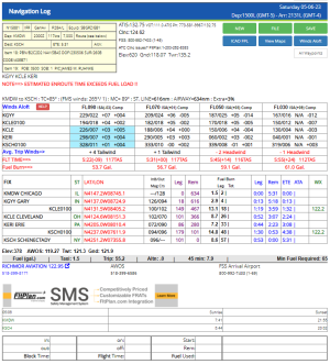
For an apples-to-apples comparison, see below for MDreger's flight plan as shown by fltplan.com.

A few things to note:
  • I am warned at the top IN ALL CAPS RED TEXT that this flight exceeds my fuel capacity.
  • Two legs are long enough that FP.com inserts additional waypoints.
    • The 249 mi leg between KGYY and KCLE gets an intermediate waypoint 100 mi out from KCLE
    • The 280 mi leg between KERI and KSCH gets an intermediate waypoint 100 mi out from KSCH
    • This is mostly important from a legacy standpoint, but would still apply to anyone flying by pilotage without electronic navaids. You can see that over those long legs, the magnetic course actually changes rather substantially. The intermediate waypoints include updated magnetic course numbers to help keep you on track.
      • Note how when you pass the KGYY waypoint, your outbound magnetic course is 094, but when you arrive at KCLE, it's 102
      • Similarly, when you depart the KERI waypoint, your magnetic course is 090, but by the time you arrive at KSCH, it's 096.
  • With ADSB-in, the winds information is not so important anymore, but that was extremely handy in the days before ADSB-in. I look at that info pre-flight to help pick my cruise altitude(s), but in practice I don't look at it during flight, unless I can't get wind data via ADSB.
    • One thing that's handy in that section is at-a-glance cautions about potential icing conditions. That's what the blue highlighting is indicating in the FL090 column from KCLE to KSCH.
  • I don't use the LAT/LON data and my eyes just skip right over it.
  • I like having the comm frequencies for my departure and arrival airports handy. They take up a lot less space on this printout than on MDreger's, making them handier.
    • In practice, I often get those from iFly or my in-panel GPS navigator, but it's nice to have it on paper just in case. and I sometimes grab a freq there anyway just because I don't have to tap anything to get it. I do routinely use this info at the beginning of an IFR flight if I want to check weather or call Clearance before starting the engine and getting all my electronics up.
    • FP.com's page includes the FBOs on the field, including freqs and phone numbers. I've had flights where I couldn't remember the name of my FBO when I landed and would have cluttered up the Ground comm with my confusion, but a quick glance at the sheet got me straightened out. I've also referenced the page on ground/off-airport to get the FBO phone number.
One thing that MDreger's printout has that fltplan.com's doesn't is the block of TC/TH/MH/WCA/VAR/DEV. That would have been nice during my PPL training. With modern equipment, that's less important today though, and I haven't missed that info during my flying. I can see that being valuable to others, though.


1683392961605.png
 
Last edited:
Cobra, rather than respond directly to your comparison posts--which are illuminating--let me suggest that we're discussing a Flight Plan created in iFly and the possibility of printing it from iFly. I think that eliminates a need for comparisons for the moment. (Maybe we'll want to get back to them later, when discussing iFly features.)

What I like about iFly's Flight Plan is that it seems relatively intuitive to me. Of course, "intuitive" usually requires prior experience or training. So in this case, the experience everyone shares would probably be from using iFly. I don't know how much intuition about planning trips is genetic, but if any it probably begins with going somewhere and then remembering the details for the next time. (We humans suck at that, compared to critters who migrate for a living.) If that's so, then an iFly flight plan probably can be expected to be iFly-ish in nature.

And if THAT's so, then I think the graphics at the beginning make perfect sense. They represent the trip optically, and then from there we go to essential details, expressed as numbers. (We might want more graphics or numbers, but that's for improvements--if we can agree the the basic "iFly-ness" idea.)

Unfortunately, I have to do some Life stuff right now, so I'm going to stop and post this, so you can see what's on my mind and so I won't forget where I left off.

Well, OK, one more thing to supply a counter-view to the kind of flight planning you probably do: I went flying yesterday, 1.1 hrs. I did not file a flight plan. I did, however, have a Flight Plan of the basic, short trip in iFly. I took off from an untowered airport, flew about 15 nm to a mile-wide river with islands. I did one water landing but did not stop--instead did a circle about half a mile in diameter on the step, at about 35 mph, then powered up and flew to an archipelago of 5 or 6 low islands and did a slalom around them in both directions. Then I climbed to about 1,000 feet and did a pair of wingovers. (Sadly, actual aerobatics are prohibited in SeaReys.) From there I flew upstream, past a boat landing and then around a large oxbow left after the channel was cut through during the Civil War to shorten the trip to Richmond. I was just looking for wildlife and enjoying the scenery. Eventually I flew back to the airport and landed. The highest I got on that trip was 1,400 MSL, and most of it was well below 1,000 feet. I didn't need a real flight plan for that trip--but I was grateful to AP for their lovely iFly, which made the navigation very easy. Down at 100 feet MSL, it's easy to get discombobulated, even if you've flown the area many times before. A quick look at the display always told me instantly which direction the airport was and where I was on the Sectional chart. I don't mean that most iFly customers probably make short trips like that--but just want to suggest an extreme different from your equally valid one. I think iFly needs to accommodate both extremes and everything in between.

Back later.
 
Well, OK, one more thing to supply a counter-view to the kind of flight planning you probably do: I went flying yesterday, {snipped description of casually flying around} I don't mean that most iFly customers probably make short trips like that--but just want to suggest an extreme different from your equally valid one. I think iFly needs to accommodate both extremes and everything in between.
Yes, I occasionally fly VFR with no particular plan in mind, too. I neither file nor print a flight plan for those flights, even though I might tap in some waypoints to make a flight plan in the iFly app, though I don't always do that either.

Not sure how that's relevant to the discussion of planning a specific flight and wanting a printout of it, though.
 
Last edited:
And if THAT's so, then I think the graphics at the beginning make perfect sense. They represent the trip optically, and then from there we go to essential details, expressed as numbers. (We might want more graphics or numbers, but that's for improvements--if we can agree the the basic "iFly-ness" idea.)
When would you actually want to look at a graphical printout of your flight, instead of looking at it on the screen on your iFly?

I can maybe see that being useful for your wife. I don't see that being particularly useful for the pilot.

Personally, once I stopped manually plotting flights on paper sectional charts, I've never felt the need to print out a map of my flight. I stopped using paper charts because I have multiple electronic devices with multiple power backups, and any graphical representation of my flight I could want to see is either already right in front of me, or is only a couple of taps away.

On the rare occasions I've wanted to share a picture of my route with someone else, I've either sent a screenshot of the route in iFly, or occasionally I've re-built the flight plan in Skyvector.com and shared a link to it there. I've never wished I could hand a printout of it to someone. (I don't have a need to share my routes with others very often, but when I do, it's always with someone who is physically not near me, so to get them a paper copy I'd have to go old-school and fax or mail it.)
 
Last edited:
I think the graphical print out (or copy/paste/email) portion of the flight is more useful for the non-pilot significant other who is at home and wondering what your general route is/was supposed to be in case you don't report in as expected. The flight log and associated airport/route/FBO information is handy to have on the clipboard for reasons noted above by both Cobra and Don. I too use the multiple devices with multiple power sources strategy so I don't worry about not having paper charts in the plane.

I think I've only filed a flight plan with Leidos three times in the past 7 years of flying as I do the VFR wander type of flying 95% of the time. I have however learned to open and close my flight activities/plan with my wife after a rather stern discussion that took place after I wandered around for 2.5 hours on an absolutely beautiful day that I had said I'd only be up for an hour... or so. The "or so" had me in hot water for a bit. I also learned that my wife's clock was starting about 40 minutes after I left the house and didn't account for refueling, preflight checks, and chatting with my hangar neighbors. I've since improved my reporting performance and include an outline of my planned route/activities such as out to the island, along the channel, go look at birds, practice water landings, etc... A lot of my flying looks like this: (oh, look a dolphin!)
1683497332927.png

I could get used to throwing in a couple of way points or loading in a pre-planned route and be able to hit "send" and have it email/text a picture of the route and very basic flight info from my phone or tablet to selected recipients while I'm finishing off my warm-up.

These are the components I'd like to be able to print out for the clipboard and/or paste in to my tablet for the pilot's use: (completely open on the format and layout).
1683495606945.png
1683495638366.png
although I like the format below a lot - very clean and simple. Seems like the main thing missing is cruise altitudes:
1683495981488.png
1683495734068.png
Tony
 
Last edited:
Yeah, fltplan.com only bothers with one altitude, for flight plan filling purposes.
 
I think the graphical print out (or copy/paste/email) portion of the flight is more useful for the non-pilot significant other who is at home and wondering what your general route is/was supposed to be in case you don't report in as expected.
I guess I just find it (very) surprising that in 2023 the best solution to that problem is to have a "print" function in iFly. That seems like a very 1990s solution. We all have cell phones these days, right? Texting a screenshot (or even a few screenshots, if the route is long and you need to zoom in for readability) really isn't a better option?

I think I've only filed a flight plan with Leidos three times in the past 7 years of flying as I do the VFR wander type of flying 95% of the time. I have however learned to open and close my flight activities/plan with my wife after a rather stern discussion that took place after I wandered around for 2.5 hours on an absolutely beautiful day that I had said I'd only be up for an hour... or so. The "or so" had me in hot water for a bit. I also learned that my wife's clock was starting about 40 minutes after I left the house and didn't account for refueling, preflight checks, and chatting with my hangar neighbors.
I don't have a wife, but I do have family and friends who "stalk" me when I go flying. I used to get texts from the "worryingest" ones asking me to send a text when I got home so they knew I landed safely. I have since solved that problem by setting folks up with (free) flightaware.com accounts, and auto-texts from FA to status them on my flights. They also know how to pull up FA.com and track me in real-time if they want to. That works well for me because I'm fully ADSB-out compliant and fly where there's solid ADSB coverage. Maybe for the kind of flying you and Don do, that wouldn't work so well because you're "off the grid", down real low and maybe where there aren't a lot of towers...?

I could get used to throwing in a couple of way points or loading in a pre-planned route and be able to hit "send" and have it email/text a picture of the route and very basic flight info from my phone or tablet to selected recipients while I'm finishing off my warm-up.
I suppose I can see the utility of this for interested non-pilot parties, but I wonder how big the demand is for this? And "email or text" makes a lot more sense to me than "print", though maybe all three options would be appropriate. (I do wonder about the potential complication of "printing" from the variety of phones and tablets out there. That's not a ubiquitous OS feature for those devices like it is for Windows and MacOS.)

I am also wondering if we're potentially talking about multiple report formats..."simplified" ones for non-pilots, and more thorough ones for pilots?

Or maybe (and I can hear @Brian cringing already), customizable reports where you can insert, remove, or re-order data modules as you see fit, akin to how the Instrument customization works on the main map?
 
Last edited:
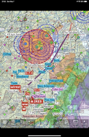
All right, here's a relatively simple VFR trip I made recently that illustrates some of the things to consider when flying in the Mid-Atlantic. First, the map:

1683510919998.png

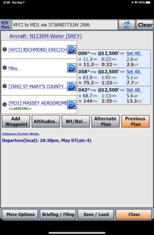
It's from KFCI (paved, untowered) to MD1 (Massey Aerodrome, turf), my first time there. Along the way there's the ugly DC thing and lots of Restricted areas. And the Chesapeake Bay and PAX River NAS. The winds and times in the printout below are the defaults for the time I made the screenshot. When I made the trip, the wind was from the SW, so I cruised at 12,500 and came back later in the day at "1,000" feet, but most of that was at 500 feet and lower still over the Bay.

1683510154796.png

I printed out the screenshots for my wife--the Altitude screen, too, which she seems to find comfort in. Then I printed a second copy of the navlog for myself. I used the space at the bottom to draw a schematic of the destination field--just a line for the runway, with the numbers at the ends, and the CTAF, 122.9. I even drew an arrow for my probable approach direction. I've been doing that for unfamiliar airfields since I was a student pilot and find it helps me considerably with situational awareness. Sure, the GPS has that and more; but the act of drawing it with a pen or pencil helps to keep my head on straight. That little diagram is the same, regardless of the devices I'm using for navigation. If I don't print a navlog, I still make the drawing.

My wife and I had PAX River jam the GPS signal once, just as we were in the middle of the Bay. Fortunately, I knew where we were and our heading to pass through the narrow gap between PAX River River R-4007 and the DC SFRA, so we just motored on, and the GPS came back up about 70 miles later. But it was a powerful lesson for me, and is the reason why I don't trust the electronic gizmos, not even iFly. I NEVER fly without some kind of paper help--part of a sectional from Skyvector and at the very least a hand-written navlog with courses, bearings, headings, and times.

The flight plan (navlog) printout usually seems to comfort my wife, even though she doesn't pay much attention to the right side of it. She wants to know where I'm going and what I'll pass along the way. She'd probably like more detail, but this much seems to be enough. I might add that she has flown with me on several long-ish SeaRey trips--to Florida, to the Georgian Bay in Canada, the Glenn Curtiss seaplane pilgrimage to Hammondsport, NY, and around the Mid-Atlantic area. She hasn't been able to get into the SeaRey for several years because of a bad hip, but she got a nice new titanium one a few weeks ago, and may be able to get back in the air eventually.

I filed a flight plan for this trip, but didn't activate it, because I preferred the liberty to deviate--which I did liberally--to the safety of talking to ATC. (I carry a satellite gizmo to summon help if necessary.)

OK, as I said earlier, I think the organizing principle for iFly's Flight Plan is iFly, itself. That's probably Walter's original vision of the app, and our efforts toward improvement probably ought to be consonant with it.
 
OK, but focusing on "what Don wants in a 'printout' ", what I get from your last post is:
  • Including a schematic of the airport in the "printout" is not desirable, because the value to you comes from drawing it yourself
  • You got what you needed by screenshotting what's already available in iFly or Skyvector
  • You made real-time decisions to deviate from your real-time plan, which diminishes the value of a printout for someone who wants to know where you'll be
  • For some reason you hand-write your navlogs instead of screenshotting/printing the navlog from inside iFly...not sure why
The bits about whether you open a flight plan, whether you talk to ATC, etc. are not germane to the question of "what should an iFly flight plan report/'printout' look like".

Tony's post #13 above was a better example of what he thought should be included in a report/"printout". He explained what bits were important and to whom, and what formats he preferred or didn't have any particular preference for. I have a better idea of what he's looking for after reading his post.

But I still don't have a solid idea of what your "requirements" / "vision" of a flight plan report/"printout" really are. Are they for you? For your wife? And will they be appropriate for the broader iFly user community? I'm trying to see your vision, but it's still very fuzzy to me.

And I wonder if your wife would overall be better served by learning how to use a site like flightaware.com to watch where you're going in real-time. (If you're around enough ADSB towers for them to keep track of you.)
 
Last edited:
Liked the M Dreger version, but would like the option to print ALL waypoints w it, after you've run Realplan, for example, to show another pilot.
Have a friend w ipad/FF doing a coast to coast, and could not find an easy way to share the plan I created with him. Any ideas on that??
 
I too would like to be able to print the 'Flight Plan' portion of the EFB Beta version (as MDreger posted). I would have no need to print the other portions or diagrams as I use a printed AOPA/FAA airport diagram of my destination to keep the rest of the information at hand. Hopefully the calculations on the flight plan table will be corrected before an official release occurs ;).
 
Interesting information going around in this thread. I would love to have a printed NAV Log. I do not care for all of the technology, but understand some technology is not a bad thing for SA purposes. I prefer pen and paper, in order to look for trends in performance or just the satisfaction of old school pen and paper and not having an overheating iPad on my leg. Pen and paper as well as and stick and rudder are becoming a lost art, lol. In all seriousness, I try not to rely on phones, IPads or what not. I find that I have to export my flight plan to ANOTHER EFB, Foreflight. Foreflight then shows everything I just did with IFly. Seems counterintuitive to me to have to use 2 EFBs or multiple websites and lots of typing due to no cut and paste function in order to have a printed NAVLOG. A printed NAVLOG is a sought for item and is provided with all other EFBs that I evaluated. I sincerely hope this is an item that will be added into an update in the very near future.
 
I too would like to be able to print the 'Flight Plan ... Hopefully the calculations on the flight plan table will be corrected before an official release occurs ;).
Calculation errors?? Were you in the Beta version or Live Release when you got errors? What were they? So far, mine seem pretty accurate.
 
Hopefully the calculations on the flight plan table will be corrected before an official release occurs ;).

Calculation errors?? Were you in the Beta version or Live Release when you got errors? What were they? So far, mine seem pretty accurate.

The errors in question were in the "original" iFly EFB effort that has since been terminated. You can see them if you scroll back and look at the example nav log posted by MDreger.

Since that particular effort has been overcome by events and is no longer being pursued, those erroneous nav logs are no longer a concern.
 
Cobra, thanks for posting that. Saved me from running and screen capturing an example. I was running the publicly released Beta when I saw the Nav Log calculations were in error. Hoping that the enhanced Flight Plan code will be included in a future release, especially the Nav Log table. I do keep a copy of my Nav Log on my knee pad as my ultimate backup.
 
I would like something like this, so that I have something that I can take notes on on my clipboard and compare it to what I did during my flight planning. This is from 1800wxbrief.com
 

Attachments

  • samplefor ifly.pdf
    9.3 KB · Views: 14
Back
Top