It would be nice to have an instrument that automatically shows the CTAF, AWOS, TWR, etc of the closest Waypoint/Destination on your flight plan. That way in a bumpy ride it's ready for you at a glance. I've reverted to either writing them on a kneeboard or on the map before I leave. But I do forget to do that at times.
You are using an out of date browser. It may not display this or other websites correctly.
You should upgrade or use an alternative browser.
You should upgrade or use an alternative browser.
Waypoint or Destination Frequencies Instrument
- Thread starter JFCiFly
- Start date
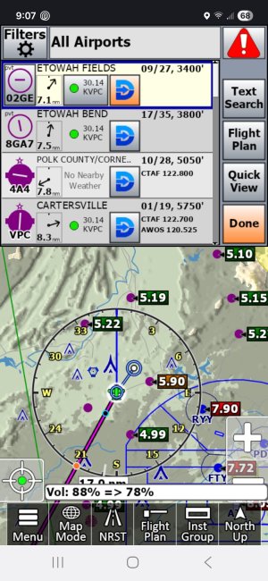
Not sure what you desire. Currently you can have an instrument that displays the next waypoint and/or destination. If you touch/click on one of those instruments, the airport information box will pop up, listing the airport name, Runway, Wind, Tower/CTAF, ATIS/AWOS/ASOS/etc. as well as buttons to get you just about whatever you'd like to know with another click or two.
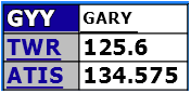
Are you envisioning an instrument that would be considerably larger than the current ones, that would have the airport ID, Tower/CTAF, and ATIS/AWOS/etc. information displayed all the time?
Something like:

Or are you hoping to have all the Wx information (Ceiling, Wind, Baro, Temp/DP, etc.) automatically displayed, as well as the tower/CTAF?
Are you envisioning an instrument that would be considerably larger than the current ones, that would have the airport ID, Tower/CTAF, and ATIS/AWOS/etc. information displayed all the time?
Something like:
Or are you hoping to have all the Wx information (Ceiling, Wind, Baro, Temp/DP, etc.) automatically displayed, as well as the tower/CTAF?
Attachments
")
And if they are not your way point or destination just hit NRST and you will find common freq and twr if they have one.It would be nice to have an instrument that automatically shows the CTAF, AWOS, TWR, etc of the closest Waypoint/Destination on your flight plan. That way in a bumpy ride it's ready for you at a glance. I've reverted to either writing them on a kneeboard or on the map before I leave. But I do forget to do that at times.