skypilot007
Member
- Joined
- Oct 7, 2023
- Messages
- 9
- Reaction score
- 0
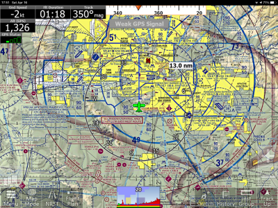
Admittedly not a techie, ive paid for ifly for several yrs now & rarely seem to use it. The continual acknowlegement requiring tapping to remove them, superimposed on each other, + alerts that my maps are out of date, those giant red chevrons indicating imminent in flight collisions, when theres not a planes in sight, just result, especially in a bit of turbulence, in too much pecking at the glass ... & not enough outside visual scanning for my taste.
Mine often goes off line somewhere in the flight, resulting in a need to close the app & reboot ???
Would be nice to have a choice for a simple screen, user customizeable for traffic only, optional alerts, w/ smaller traffic conflict symbols & a choice down to < 1 mile. I dont need or want to know whos 3 mi. behind me exiting to my 16:00, or hitting a nav. fix 2k above me.